| Added | Wed, 28/04/2021 |
| Источники | |
| Дата публикации | Wed, 28/04/2021
|
| Версии |
Now, in addition to photos and videos, artificial intelligence has learned to skillfully fake satellite maps that can be used for disinformation.
Many people are probably already familiar with the examples of falsification of videos and photos of people using Deepfake technology, in which artificial intelligence plays a major role. The resulting images with face substitution look very convincing.
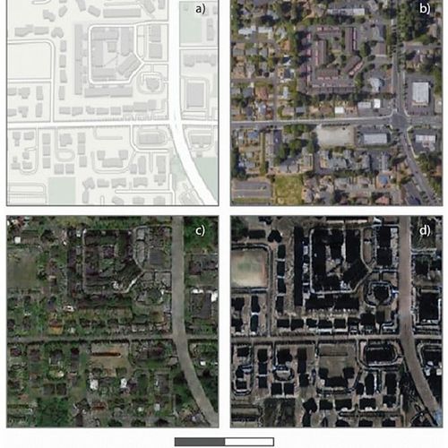
Now this approach has been applied by researchers from the University of Washington, forcing the algorithm to fake high-quality satellite maps. But initially, the experts wanted to achieve the opposite result, that is, to learn how to identify fake satellite maps, and not create fakes.
During the analysis, the neural network alternately combines various satellite images. Thanks to this, the AI has learned to superimpose buildings or streets of one city on similar objects of another city. It looks so convincing that it is hard to believe that the card is fake.
Experts believe that their technology can be useful in other areas. For example, it will help to recreate sites from the past to find out how current climate changes have affected the Earth's landscape. You can also now predict possible changes in the development of cities or regions.
However, there is another side to the application of this technology, and it causes more fears than joy. Now anyone who owns this technology can easily use it for disinformation. For example, for military purposes to hide tactically important objects from the enemy, or for political purposes, hiding (distorting) certain facts from the public, thereby manipulating its consciousness.
The researchers believe that their development will be useful for society and hope that it will not fall into the hands of intruders. Although this role is very vague in our time, especially in politics, and different parties interpret it differently.
Новости со схожими версиями
Log in or register to post comments

