| Added | Tue, 04/07/2017 |
| Источники | |
| Дата публикации | Mon, 03/07/2017
|
| Версии |
With satellite images, for example, using Google Earth Online, allow researchers the Earth to discover what is on the surface of the planet is simply not visible, for example, were found under the Sands of Nazca in the desert of Egypt.
A few days near the village of Bliznaci Smolensk region the researchers found that satellite images of a giant arrow, "drawn" in a wooded area and directed toward the regional center. The arrow is clearly visible from the top (bird's eye), since there's no trees. And if on the surface it is a common edge of the forest, "bald spots" in a forest, which nobody pays attention, the top is clearly visible well, "legible" and understandable symbol. Here only it is not clear another: who and why made it here? And most importantly, how?
The coordinates of this huge boom in Google Earth - latitude: 54°53'49.49"S, longitude: 31°58'32.99", so everyone who is interested can admire the mysterious symbol of the Smolensk region. By the way, Bliznaci is a small village with a population of just 29 people, mostly consisting of pensioners. None of them has no idea about some of the forest "the arrow", and the old-timers believe that the "bald spots" in the forest, which resembles the symbol here has always existed.
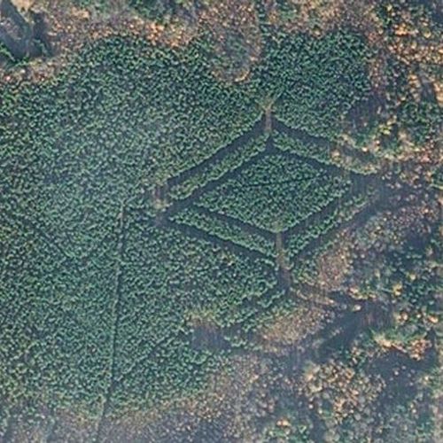
However, as it turned out, in the forests of Smolensk region is not the only mysterious character, unknown by whom and to whom made. Soon researchers pictures Google Earth found near the village of Khokhlovo even more mysterious symbol (see photo below) – as in "kite." Coordinates - latitude: 54°41'18.83"S, longitude: 31°51'1.93"V. And again: do the villagers know nothing, know do not know what they have at hand do such wonders...
Translated by «Yandex.Translator»
Новости со схожими версиями
Log in or register to post comments


